Related Publications
Evaluation of sediment connectivity through physically-based erosion modeling of landscape factor at the event scale
CATENA 213: 106165, 2022
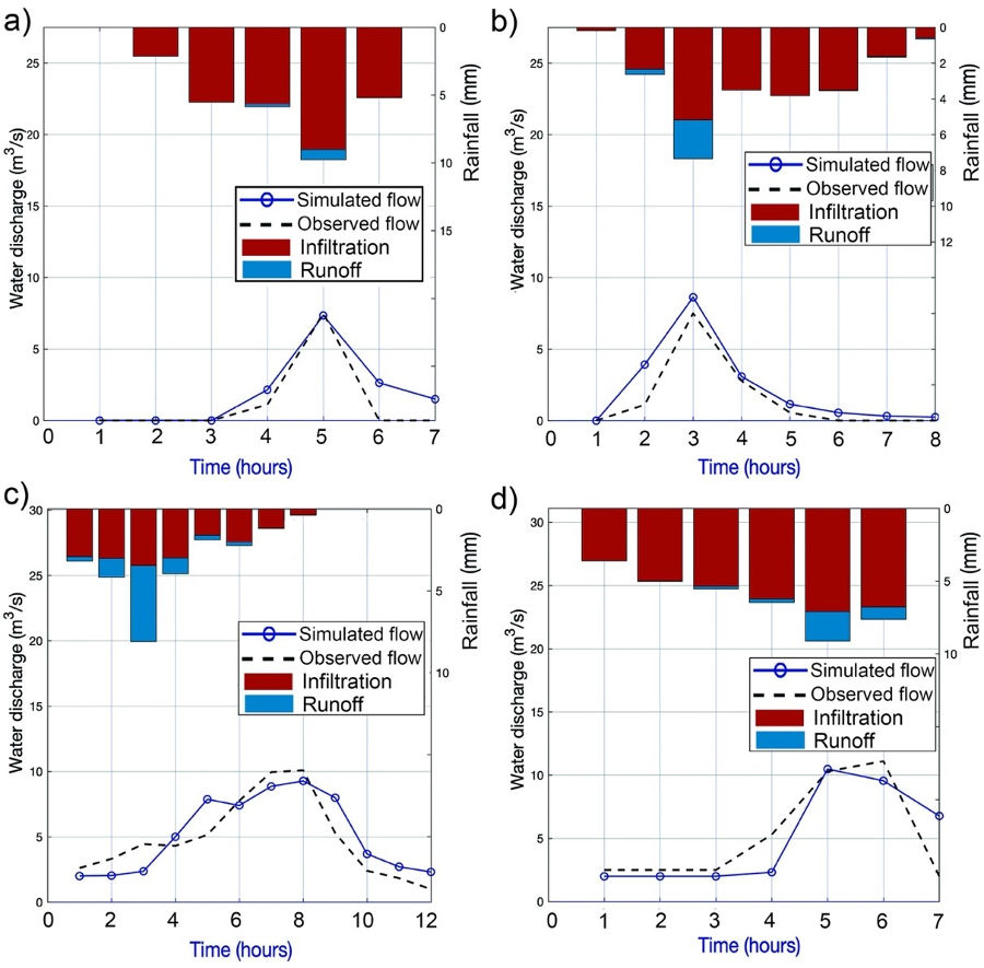
Understanding erosion and sedimentation processes along the drainage network, from hillslopes to rivers and reservoirs, is essential for water resources management and river restoration. This work proposes a novel dynamic evaluation of landscape factor from modeled runoff and erosion rates from physically-based distributed hydrological modelling, to estimate event-scale sediment connectivity. Four precipitation events of moderate intensity were selected and used for model calibration. The results were used to analyze the temporal variability of connectivity and comparison with indices based on catchment relief or land-uses. Although the headwater areas of the hillslopes presented similar values for all simulated events, a progressive increase in sediment connectivity, proportional to the runoff magnitude of the event, was observed. The variability of the event-scale connectivity index was mainly controlled by parameters related to flow (riverbed roughness, rill erodibility and particle diameter) and less by land use and vegetation cover (cover fraction or interrill erodibility). Although features affecting functional connectivity caused variations between events, the obtained results agreed with indices based on relief as landscape factor. This highlights the important role of structural connectivity represented by the catchment topography. However, the proposed methodology is subject to several sources of uncertainty related to event-scale model calibration, the erosion and transport processes considered and the spatial distribution of runoff. Furthermore, the geomorphological threshold for hillslope and rivers can also affect sediment connectivity, especially along the fluvial system. The results of this work highlight important future challenges in a more dynamic understanding of sediment connectivity river basins.

Assessment of Streamflow from EURO-CORDEX Regional Climate Simulations in Semi-Arid Catchments Using the SWAT Model
Sustainability 13 (13): 7120, 2021
This research studies the effect of climate change on the hydrological behavior of two semi-arid basins. For this purpose the SWAT model was used, with the simulation of two future climate change scenarios, one moderate (RCP 4.5) and the other extreme (RCP 8.5).Three future periods were considered: close (2019-2040), medium (2041-2070), and distant (2071-2100). Also, several climatic projections of the EURO-CORDEX model were selected, to which different bias correction methods were applied before incorporation into the SWAT model. The statistical indices for the monthly flow simulations showed a very good fit in the calibration and validation phases in the Upper Mula stream (NS = 0.79 - 0.87; PBIAS = -4.00% - 0.70%; RSR = 0.44 - 0.46) and the ephemeral Algeciras stream (NS = 0.78 - 0.82; PBIAS = -8.10% - -8.20%; RSR = 0.41- 0.42). Subsequently, the impact of climate change in both basins was evaluated by comparing future flows with those of the historical period. In the RCP4.5 and RCP8.5 scenarios, by the end of the 2071-2100 period the flows of the Upper Mula stream and the ephemeral Algeciras stream will have decreased by between 45.16% and 59.35% and between 45.89% and 63.85%, respectively.
A process-based soil erosion model ensemble to assess model uncertainty in climate change impact assessments
Land Degradation & Development 32 (7): 2409-2422, 2021
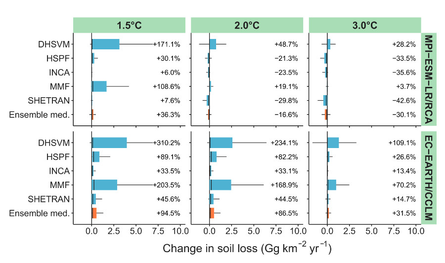
The impact of climate change on future soil loss is commonly assessed with soil erosion models, which are suggested to be an important source of uncertainty. Here we present a novel soil erosion model ensemble to assess model uncertainty in climate change impact assessments. The model ensemble consisted of five continuous process-based soil erosion models that run at a daily time step (i.e. DHSVM, HSPF, INCA, MMF, SHETRAN). The models were implemented in the SPHY hydrological model and simulate detachment by raindrop impact, detachment by runoff and immediate deposition. The soil erosion model ensemble was applied in a semi-arid catchment in the southeast of Spain. We applied three future climate scenarios based on global mean temperature rise (+1.5, +2 and +3 °C). Data from two contrasting regional climate models were used to assess how an increase and a decrease in projected extreme precipitation affect model uncertainty. Soil loss is projected to increase (up to 95%) and decrease (up to -30%) under climate change, mostly reflecting the change in extreme precipitation. Model uncertainty is found to increase with increasing slope, extreme precipitation and runoff, which reveals some inherent differences in model assumptions among the five models. Moreover, the model uncertainty increases in all climate change scenarios, independent of the projected change in annual precipitation and extreme precipitation. This stresses the importance to consider model uncertainty through model ensembles of climate, hydrology, and soil erosion in climate change impact assessments.

Dimensionless morphological ratios versus stream power variations at bankfull stage in an ephemeral channel
Geomorphology 361: 107199, 2020
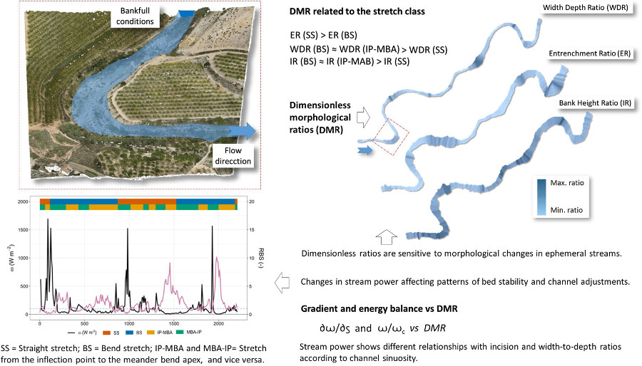
Dimensionless morphological ratios (DMR) generally are used in systemic proposals for stream classification and river restoration projects. Often, such morphometric parameters, including field data from channel cross sections, develop into a template for a given geomorphic reference site. In this study, high-resolution Digital Terrain Models (HRDTMs), combined with orthophotographs from 2018 and ground-based surveys, were used to analyze the spatial variability of DMR in a semi-arid ephemeral stream subject to changes in stream power under bankfull conditions. In particular, a channel reach of 2.7 km in length along the Upper Mula stream in southeastern Spain was chosen to test the relationships between the two types of variables. Rosgen’s DMR (width to depth ratio, entrenchment ratio, bank height ratio) and hydraulic data at bankfull stage (flow velocity, Froude number, shear stress, mean stream power and energy gradient, among others) were calculated by 1D hydrodynamic modeling and HRDTMs prior entry of field information. The resulting maps allowed comparison of stream power with DMR in relation to the channel stretch class and bed stability. The results showed similar spatial patterns for the width to depth ratio and the bank height ratio. The average values estimated in bend stretches were lower than along straight and slightly sinuous stretches and very similar to those of sub-reaches from the inflection point to the meander bend apex. However, the entrenchment ratio followed a different pattern, according to which the straight and slightly sinuous stretches were the most entrenched and the bend stretches presented a more moderate average entrenchment ratio. In addition, the energy balance and power gradient also experienced spatial variations in relation to the bed stability and DMR. Only in highly incised sub-reaches were such relationships not significant. The lack of a significant correlation between excess energy and bank height ratio or width to depth ratio over short lag distances was also verified, regardless of the affected bedforms. An ANOVA showed important differences between the straight and slightly sinuous stretches and bend stretches, which were strongly influenced by the incision and entrenchment ratios and the maximum bankfull depth.
