Related Publications
Mountain ecosystem services affected by land use changes and hydrological control works in Mediterranean catchments
Ecosystem Services 44: 101136, 2020
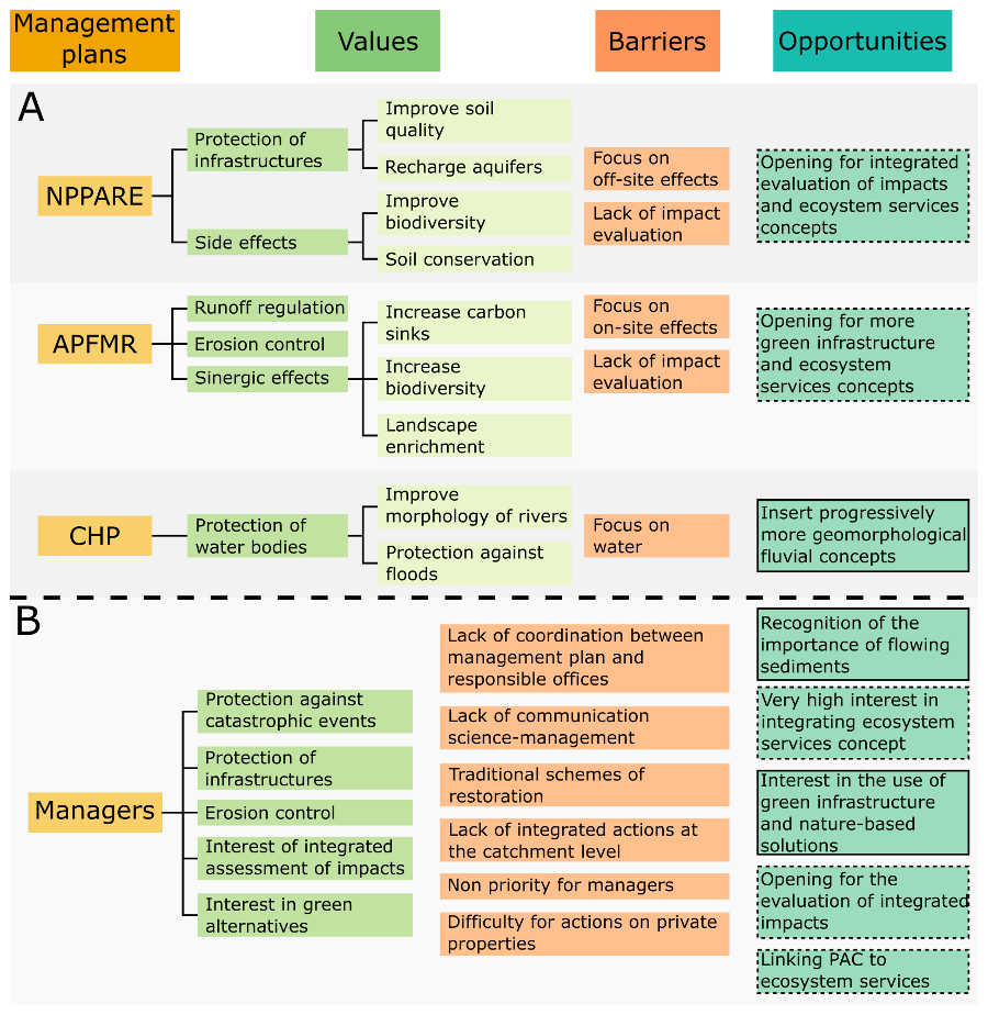
The use of check-dams in mountain environments to regulate fluxes of water and sediments is widely applied across Mediterranean mountains. Besides the use of “grey infrastructures” such as check-dams, other restoration and hydrological control measures rely more on the use of “green infrastructures” or “nature-based solutions” (e.g. reforestation, buffer lines) or a combination of both types of measures. It is widely accepted that both are complementary, and that prioritization should be based on economic, ecological and cultural criteria. This paper brings together all the knowledge generated during more than one decade concerning the impact of land use changes, reforestation, and hydrological control works on several ecosystem services in a representative Mediterranean catchment. The work evaluates different management scenarios aiming to optimize provision of ecosystem services in the area. The study area is a medium-sized catchment (∼300 km2) in Southeast Spain, representative of Mediterranean mountains that experienced agricultural land abandonment, greening up, and restoration works in the second half of the twentieth century. The methods combined: (i) previous research results for the area that were organized in an ecosystem services framework, providing data for three representative scenarios of catchment management; (ii) the use of value content analysis of the existing management plans for the area to understand the view of the managers; and (iii) a multicriteria analysis of the management scenarios to determine the most sustainable scenario to optimize different ecosystem services. The results of the evaluation were later validated with the stakeholders (technicians and managers involved in the management plans) through interviews. Our results show that solutions that respect landscape and ecological dynamics are more sustainable and cheaper in the medium and long term than scenarios based on “grey infrastructures”, although the latter could have more desirable short-term impacts. The value analysis reflects how there are some concepts, such as ecosystem services, that could easily be further incorporated into several management plans. When choosing a management scenario, this needs to be adapted to the local environmental conditions and to the specific objectives of the restoration works. Tailor-made management scenarios taking into account two factors (local conditions and specific management objectives) can optimize resources and achieve medium to long-term sustainability.

The impact of reservoir construction and changes in land use and climate on ecosystem services in a large Mediterranean catchment
Journal of Hydrology 590: 125208, 2020
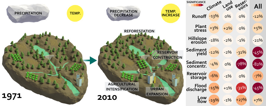
The Mediterranean region has been identified as one of the most affected global hot-spots for climate change, which is already manifested by faster increasing temperatures than the global mean and significant decreases in annual precipitation. Besides, over the past decades, important land cover changes have occurred, such as reforestation, agricultural intensification, urban expansion and the construction of many reservoirs. Here we study the impacts of these changes in a typical large Mediterranean catchment and focus on relevant ecosystem services, i.e. primary production, water supply, food production, water regulation, flood and erosion control, and cultural ecosystem services. We applied a hydrological model, coupled with a soil erosion and sediment transport model, for the period 1971-2010 to the entire catchment, and for an extended period (1952-2018), with more pronounced land use changes, to one of its subcatchments that plays a crucial role for regional drinking water provision. Climate change in the evaluated period is characterized by a decrease in precipitation and an increase in temperature. Land use changes included an increase in natural vegetation in the headwaters, agricultural intensification and reservoir construction in the central part, and urban expansion in the downstream part of the catchment. The positive impacts on ecosystem services were quantified by a decrease in hillslope erosion, sediment yield, sediment concentration and flood discharge, which are mainly attributed to climate change and reservoir construction. The negative impacts were quantified by an increase in plant water stress and a decrease in reservoir storage, for which the latter is mainly attributed to reforestation in the headwater catchments. While grey infrastructures like reservoir construction showed important positive impacts on some ecosystem services, such as water regulation and flood control, they also potentially induce negative impacts, such as an increase of water demand and ecological integrity. We argue that a shift is needed to green infrastructures and nature based solutions, such as reforestation and sustainable land management, which may lead to similar benefits on ecosystem services, but without the negative impacts caused by grey infrastructures. This supports the need for integrated land-use management to sustainably protect ecosystem services, considering the expected climate change impacts on Mediterranean environments and societies.

How soil erosion model conceptualization affects soil loss projections under climate change
Progress in Physical Geography 44 (2): 212-232, 2020
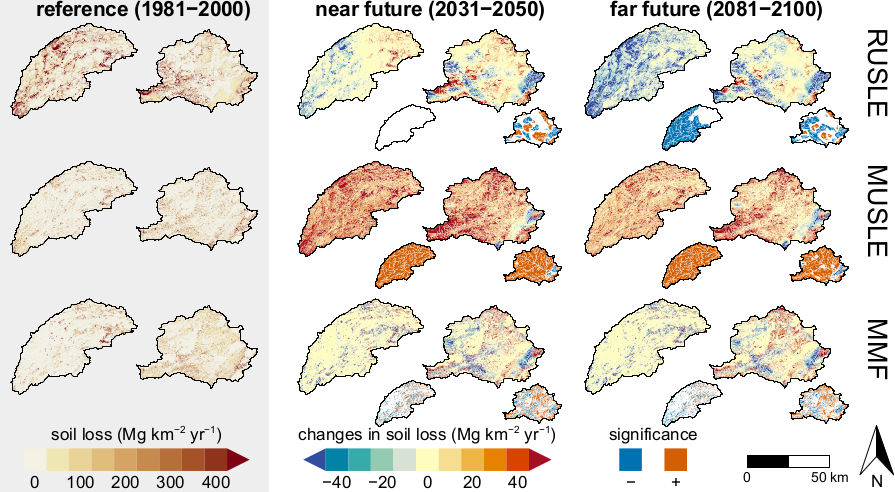
Climate models project increased extreme precipitation for the coming decades, which may lead to higher soil erosion in many locations worldwide. Different soil erosion model concepts are used to assess the impact of climate change on soil erosion at large spatial scales, including models forced by precipitation and by runoff. However, there is little knowledge of the implications of soil erosion model conceptualization on projected soil erosion rates under climate change. Here we assessed the impact of climate change with the three most widely used soil erosion model concepts, i.e. a model forced by precipitation (RUSLE), a model forced by runoff (MUSLE), and a model forced by precipitation and runoff (MMF). We applied the models to two contrasting Mediterranean catchments (SE Spain), where climate change is projected to decrease the annual precipitation sum and increase extreme precipitation, based on the RCP8.5 climate change scenario. Depending on the model, soil erosion is projected to decrease (RUSLE) or increase (MUSLE and MMF) in the study area. While it is difficult to validate future model projections, the differences between the model projections are inherently a result of their model conceptualization, such as a decrease of soil loss due to decreased annual precipitation sum (RUSLE) and an increase of soil loss due to increased extreme precipitation and, consequently, increased runoff (MUSLE). An intermediate result is obtained with MMF, where a projected decrease in detachment by raindrop impact is counteracted by a projected increase in detachment by runoff. We conclude that in climate change impact assessments it is important to select a soil erosion model that is forced by both precipitation and runoff, which under climate change may have a contrasting effect on soil erosion.

United Nations World Water Development Report 2020: Water and Climate Change
UNESCO, Paris: 235 p., 2020
The 2020 edition of the World Water Development Report (WWDR 2020) entitled ‘Water and Climate Change’ aims at helping the water community to tackle the challenges of climate change and informing the climate change community about the opportunities that improved water management offers in terms of adaptation and mitigation. The scientific evidence is clear: the climate is changing and will continue to change, affecting societies mainly through water. Climate change will affect the availability, quality and quantity of water for basic human needs, threatening the effective enjoyment of the human rights to water and sanitation for potentially billions of people. The alteration of the water cycle will also pose risks for energy production, food security, human health, economic development and poverty reduction, thus seriously jeopardizing the achievement of the Sustainable Development Goals. The 2020 United Nations World Water Development Report focuses on the challenges, opportunities and potential responses to climate change, in terms of adaptation, mitigation and improved resilience that can be addressed through improving water management. Combining climate change adaptation and mitigation, through water, is a win-win proposal, improving the provision of water supply and sanitation services and combating both the causes and impacts of climate change, including disaster risk reduction.
Land Degradation (Chapter 4). In: Climate Change and Land: an IPCC special report on climate change, desertification, land degradation, sustainable land management, food security, and greenhouse gas fluxes in terrestrial ecosystems
IPCC special report: 92 p., 2019
The implications of bias-correction methods and climate model ensembles on soil erosion projections under climate change
Earth Surface Processes and Landforms 44 (5): 1137-1147, 2019
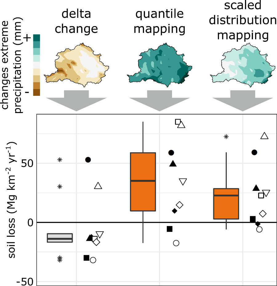
Climate change will most likely cause an increase of extreme precipitation and consequently an increase of soil erosion in many locations worldwide. In most cases, climate model output is used to assess the impact of climate change on soil erosion, however, there is little knowledge of the implications of bias‐correction methods and climate model ensembles on projected soil erosion rates. Using a soil erosion model, we evaluated the implications of three bias‐correction methods (delta change, quantile mapping and scaled distribution mapping) and climate model selection on regional soil erosion projections in two contrasting Mediterranean catchments. Depending on the bias‐correction method, soil erosion is projected to decrease or increase. Scaled distribution mapping best projects the changes in extreme precipitation. While an increase in extreme precipitation not always results in increased soil loss, it is an important soil erosion indicator. We suggest to first establish the deviation of the bias‐corrected climate signal with respect to the raw climate signal, in particular for extreme precipitation. Furthermore, individual climate models may project opposite changes with respect to the ensemble average, hence, climate model ensembles are essential in soil erosion impact assessments to account for climate model uncertainty. We conclude that the impact of climate change on soil erosion can only accurately be assessed with a bias‐correction method that best reproduces the projected climate change signal, in combination with a representative ensemble of climate models.
