Peer-reviewed Publications
Using quantile mapping and random forest for bias-correction of high-resolution reanalysis precipitation data and CMIP6 climate projections over Iran
International Journal of Climatology 44 (12): 4495-4514, 2024
Climate change is expected to cause important changes in precipitation patterns in Iran until the end of 21st century. This study aims at evaluating projections of climate change over Iran by using five climate model outputs (including ACCESS-ESM1-5, BCC-CSM2-MR, CanESM5, CMCC-ESM2 and MRI-ESM2-0) of the Coupled Model Intercomparison Project phase 6 (CMIP6), and performing bias-correction using a novel combination of quantile mapping (QM) and random forest (RF) between the years 2015 and 2100 under three shared socioeconomics pathways (SSP2-4.5, SSP3-7.0 and SSP5-8.5). First, bias-correction was performed on ERA5-Land reanalysis data as reference period (1990–2020) using the QM method, then the corrected ERA5-Land reanalysis data was considered as measured data. Based on the corrected ERA5-Land reanalysis data (1990–2020) and historical simulations (1990–2014), the future projections (2015–2100) were also bias-corrected utilizing the QM method. Next, the accuracy of the QM method was validated by comparing the corrected ERA5-Land reanalysis data with model outputs for overlapping years between 2015 and 2020. This comparison revealed persistent biases; hence, a combination of QM-RF method was applied to rectify future climate projections until the end of the 21st century. Based on the QM result, CMCC-ESM2 revealed the highest RMSE in both SSP2-4.5 and SSP3-7.0 amounting to 331.74 and 201.84 mm·year−1, respectively. Particularly, the exclusive use of the QM method displayed substantial errors in projecting annual precipitation based on SSP5-8.5, notably in the case of ACCESS-ESM1-5 (RMSE = 431.39 mm·year−1), while the RMSE reduced after using QM-RF method (197.75 mm·year−1). Obviously, a significant enhancement in results was observed upon implementing the QM-RF combination method in CMCC-ESM2 under both SSP2-4.5 (RMSE = 139.30 mm·year−1) and SSP3-7.0 (RMSE = 151.43 mm·year−1) showcasing approximately reduction in RMSE values by 192.43 and 50.41 mm·year−1, respectively. Although each bias-corrected model output was evaluated individually, multi-model ensemble (MME) was also created to project the annual future precipitation pattern in Iran. By considering that combination of QM-RF method revealed the lower errors in correcting model outputs, we used the QM-RF technique to create the MME. Based on SSP2-4.5, the MME climate projections highlight imminent precipitation reductions (>10%) across large regions of Iran, conversely projecting increases ranging from 10% to over 20% in southern areas under SSP3-7.0. Moreover, MME projected dramatic declines under SSP5-8.5, especially impacting central, eastern, and northwest Iran. Notably, the most pronounced possibly decline patterns are projected for arid regions (central plateau) and eastern areas under SSP2-4.5, SSP3-7.0 and SSP5-8.5.

The IAHS Science for Solutions decade, with Hydrology Engaging Local People IN a Global world (HELPING)
Hydrological Sciences Journal 69 (11): 1417-1435, 2024
The new scientific decade (2023-2032) of the International Association of Hydrological Sciences (IAHS) aims at searching for sustainable solutions to undesired water conditions - may it be too little, too much or too polluted. Many of the current issues originate from global change, while solutions to problems must embrace local understanding and context. The decade will explore the current water crises by searching for actionable knowledge within three themes: global and local interactions, sustainable solutions and innovative cross-cutting methods. We capitalise on previous IAHS Scientific Decades shaping a trilogy; from Hydrological Predictions (PUB) to Change and Interdisciplinarity (Panta Rhei) to Solutions (HELPING). The vision is to solve fundamental water-related environmental and societal problems by engaging with other disciplines and local stakeholders. The decade endorses mutual learning and co-creation to progress towards UN sustainable development goals. Hence, HELPING is a vehicle for putting science in action, driven by scientists working on local hydrology in coordination with local, regional, and global processes.

How future changes in irrigation water supply and demand affect water security in a Mediterranean catchment
Agricultural Water Management 297: 108818, 2024
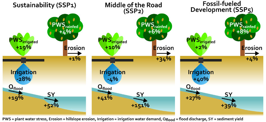
It is likely that climate change will increase irrigation water demand and, consequently, reduces water security in the Mediterranean Basin if current irrigation supply and demand conditions are maintained. Climate change adaptation can be achieved by (1) decreasing irrigation water demand through more efficient irrigation techniques, (2) increasing irrigation water supply by adopting new technological advances, (3) converting to rainfed agriculture, and (4) implementation of Nature-based Solutions for water retention. The aim of this study was to assess the effectiveness of different combinations of these adaptation options on water security through analysis of contrasting scenarios of socio-economic development. We defined plausible scenarios of climate change, land use change and adaptation measures for an intensively irrigated catchment in south-eastern Spain under three Shared Socioeconomic Pathways (SSP), representing different storylines of socio-economic development. We considered three SSP scenarios, including the Sustainability pathway (SSP1), the Middle of the Road pathway (SSP2) and the Fossil-fueled Development pathway (SSP5). Future land use distributions were obtained with the iClue land use change model by accounting for differences in irrigation water demand and supply, resulting in a decrease (SSP1), a constant (SSP2) and an increase (SSP5) in irrigated agriculture. The impact of each scenario on a series of water security indicators was quantified using the SPHY-MMF hydrology-soil erosion model. The SSP2 scenario, which considers very limited climate change adaptation, projects the most severe impacts on water security, including an increase in plant water stress, flood discharge, hillslope erosion and sediment yield. Under SSP1, which accounts for most climate change adaptation strategies, irrigation water demand is significantly reduced due to a shift from irrigated to rainfed agriculture and the implementation of reduced deficit irrigation, while Nature-based Solutions reduce the impact on other water security indicators. Under SSP5, a conversion from rainfed to irrigated agriculture causes a significant increase in irrigation water demand, which is met by increasing irrigation water supply from desalination. SSP5 shows intermediate impacts on other water security indicators, which is explained by a strong decrease in annual precipitation. This study helps exploring how different future socio-economic pathways affect water security and thereby supports evidence-based policy development.
How the EU Soil Observatory contributes to a stronger soil erosion community
Environmental Research 248: 118319, 2024
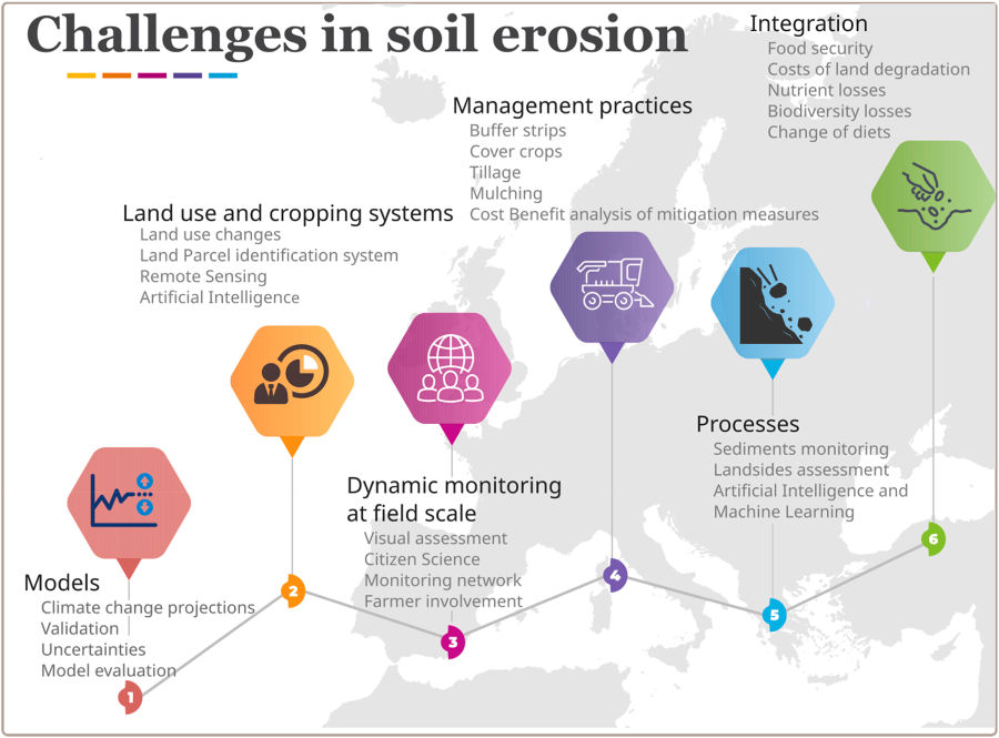
New policy developments have emerged in relation to soil conservation after 2020. The Common Agricultural Policy (CAP) 2023–2027, the proposal for a Soil Monitoring Law and the mission ‘A Soil Deal for Europe’ have shaped a new policy framework at EU level, which requires updated assessments on soil erosion and land degradation. The EU Soil Observatory (EUSO) successfully organised a scientific workshop on ‘Soil erosion for the EU’ in June 2022. The event has seen the participation of more than 330 people from 63 countries, addressing important topics such as (i) management practices, (ii) large scale modelling, (iii) the importance of sediments in nutrient cycle, (vi) the role of landslides and (v) laying the foundations for early career scientists. As a follow up, among the 120 abstracts submitted in the workshop, we received fifteen manuscripts, out of which nine were selected for publication in the present special issue. In this editorial, we summarize the major challenges that the soil erosion research community faces in relation to supporting the increasing role of soils in the EU Green Deal.
Assessing the hillslope-channel contributions to the catchment sediment balance under climate change
Environmental Modelling & Software 171: 105890, 2024
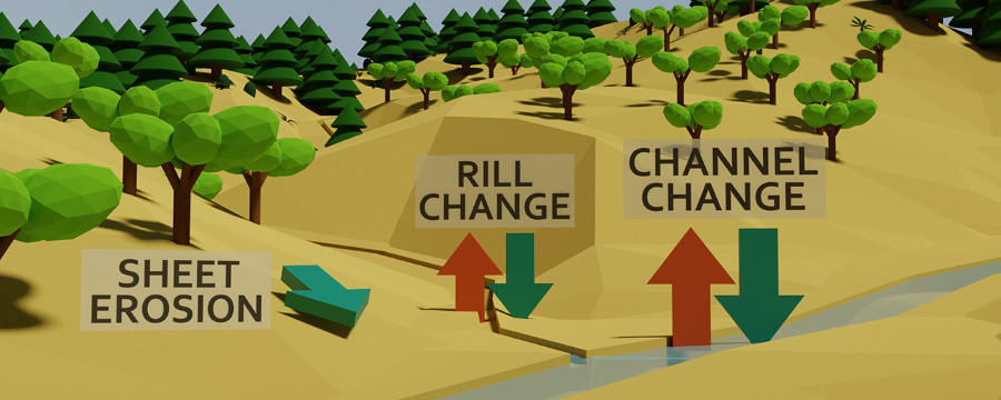
To get a full understanding of the impacts of global change on the catchment-scale sediment balance, models are needed that combine hillslope soil erosion processes with channel morphodynamics. Here we present a modification to the SPHY-MMF model that includes a novel channel morphodynamics module, which determines erosion and deposition in rills and channels. We applied the model to a Mediterranean study area in southeast Spain, in which we show that channel erosion contributes substantially (35%–40%) to the total sediment yield, highlighting the importance of accounting for channel erosion in catchment-scale sediment budget estimations. The climate change scenarios show that the different erosional processes (i.e. sheet, rill, channel) are projected to decrease or increase, depending on the projected change in annual and extreme precipitation. From this we conclude that interactions between different erosional and depositional processes should be considered when studying the impact of global change on the catchment-scale sediment balance.
The potential and challenges of the ‘RUSLE-IC-SDR’ approach to identify sediment dynamics in a Mediterranean catchment
CATENA 233: 107480, 2023
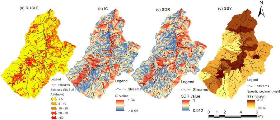
Soil erosion is a natural process that can be accelerated by natural and anthropogenic disturbances and lead to land degradation and geomorphological changes. Analyzing soil erosion and catchment sediment dynamics is a complex process. In such cases, simplified methods can be applied to analyze soil erosion and sediment connectivity variations and to understand sediment flux in a river basin to inform watershed management. In this study, we tested the combined method of the Revised Universal Soil Loss Equation (RUSLE), the Index of Connectivity (IC), and the Sediment Delivery Ratio (SDR) to estimate sediment yield (SY) and investigate the spatiotemporal variation of soil erosion rates and sediment connectivity in the Mediterranean Rogativa catchment (∼53 km2), Southeast Spain. In this ‘RUSLE-IC-SDR’ approach, the sediment delivery ratio was estimated from the spatially distributed index of connectivity, calculated using SedInConnect and accounting for the trapping efficiency of 58 check dams in the channels, while assuming 100 % sediment delivery in other parts of the channels. The sediment delivery ratio was calibrated, and sediment yield was verified for the year 2001 using observed sediment yield (in 2003) behind the non-silted check dams. Predicted soil erosion, connectivity (IC, SDR, and SY), and soil erosion-connectivity maps were quantified and compared over time and space, revealing the impacts of rainfall, land use, and check dams. These maps show higher values for areas closer to the channels than on the hillslopes, and higher values on croplands than other land use types, as well as a decrease over time due to land use change and the construction of check dams. The relatively simple ‘RUSLE-IC-SDR’ approach was found to be effective in identifying the sources and hotspots on the hillslopes of a complex Mediterranean catchment. Future studies should consider the channel erosion processes as the RUSLE-IC-SDR does not take these into account.
Evaluation of sediment connectivity through physically-based erosion modeling of landscape factor at the event scale
CATENA 213: 106165, 2022
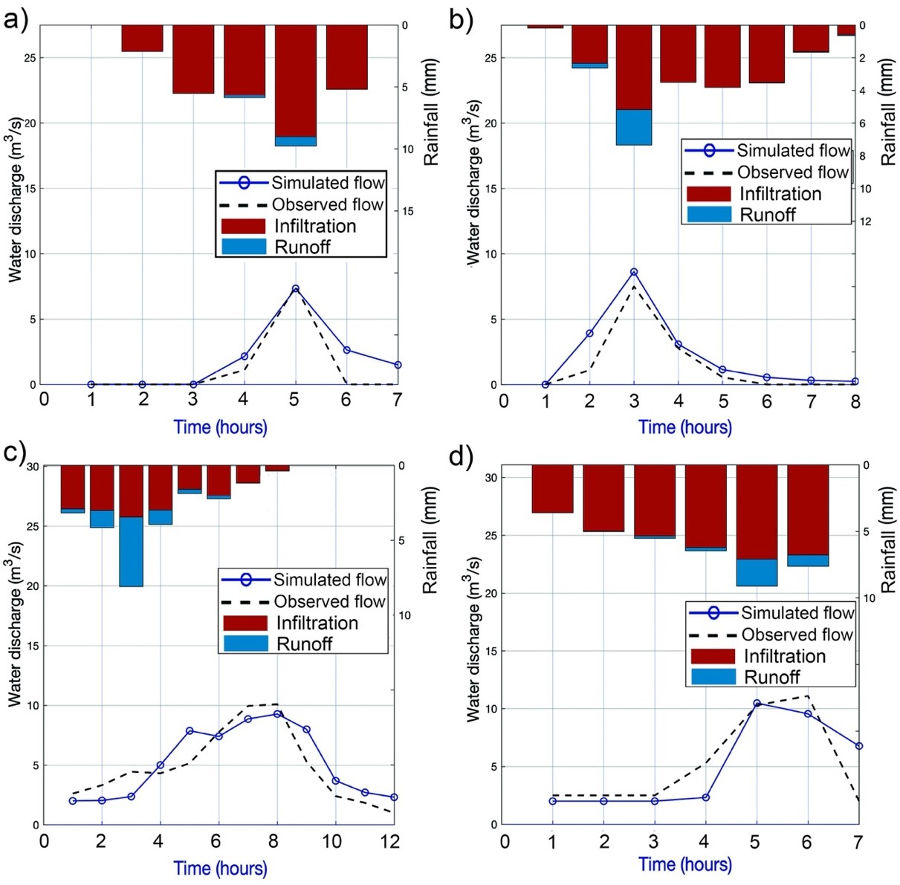
Understanding erosion and sedimentation processes along the drainage network, from hillslopes to rivers and reservoirs, is essential for water resources management and river restoration. This work proposes a novel dynamic evaluation of landscape factor from modeled runoff and erosion rates from physically-based distributed hydrological modelling, to estimate event-scale sediment connectivity. Four precipitation events of moderate intensity were selected and used for model calibration. The results were used to analyze the temporal variability of connectivity and comparison with indices based on catchment relief or land-uses. Although the headwater areas of the hillslopes presented similar values for all simulated events, a progressive increase in sediment connectivity, proportional to the runoff magnitude of the event, was observed. The variability of the event-scale connectivity index was mainly controlled by parameters related to flow (riverbed roughness, rill erodibility and particle diameter) and less by land use and vegetation cover (cover fraction or interrill erodibility). Although features affecting functional connectivity caused variations between events, the obtained results agreed with indices based on relief as landscape factor. This highlights the important role of structural connectivity represented by the catchment topography. However, the proposed methodology is subject to several sources of uncertainty related to event-scale model calibration, the erosion and transport processes considered and the spatial distribution of runoff. Furthermore, the geomorphological threshold for hillslope and rivers can also affect sediment connectivity, especially along the fluvial system. The results of this work highlight important future challenges in a more dynamic understanding of sediment connectivity river basins.
Global impact of climate change on soil erosion and potential for adaptation through soil conservation
Earth-Science Reviews 226: 103921, 2022
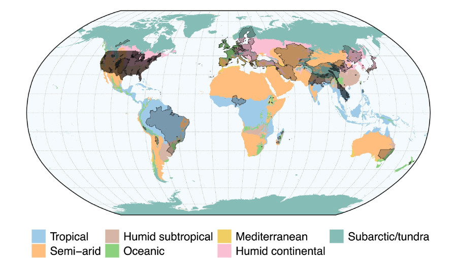
Climate change is expected to lead to increased soil erosion in many locations worldwide affecting ecosystem services and human well-being. Through a systematic review of 224 modelling studies, we provide a global assessment of the impact of climate change on soil erosion and the adaptation potential through land use change and soil conservation. We account for the robustness of each study based on a statistical analysis of ten methodological aspects and an expert consultation. Results show a global increasing trend in soil erosion towards the end of the 21st century, with the highest increase projected in semi-arid regions. Land use change characterized by agricultural expansion and deforestation aggravate the impact. Reforestation, agricultural land abandonment and soil conservation practices can entirely compensate the impact of climate change on soil erosion. This stresses the need for soil conservation and integrated land use planning. From the obtained weights per study we can conclude that there is a lot of uncertainty in the methods applied, without a clear trend towards more robust studies. Based on the results of the expert consultation, we recommend to use a climate model ensemble of at least five climate models, based on the latest CMIP6 climate scenarios. These data should be downscaled and bias corrected using trend preserving quantile methods. Finally, the post-processed climate data should be applied in a soil erosion model forced by precipitation and runoff. Considering the most robust methodologies of the different aspects of the uncertainty cascade will lead to better spatial evaluation of the impact of climate change on soil erosion and identification of most effective adaptation strategies.
Assessment of Streamflow from EURO-CORDEX Regional Climate Simulations in Semi-Arid Catchments Using the SWAT Model
Sustainability 13 (13): 7120, 2021
This research studies the effect of climate change on the hydrological behavior of two semi-arid basins. For this purpose the SWAT model was used, with the simulation of two future climate change scenarios, one moderate (RCP 4.5) and the other extreme (RCP 8.5).Three future periods were considered: close (2019-2040), medium (2041-2070), and distant (2071-2100). Also, several climatic projections of the EURO-CORDEX model were selected, to which different bias correction methods were applied before incorporation into the SWAT model. The statistical indices for the monthly flow simulations showed a very good fit in the calibration and validation phases in the Upper Mula stream (NS = 0.79 - 0.87; PBIAS = -4.00% - 0.70%; RSR = 0.44 - 0.46) and the ephemeral Algeciras stream (NS = 0.78 - 0.82; PBIAS = -8.10% - -8.20%; RSR = 0.41- 0.42). Subsequently, the impact of climate change in both basins was evaluated by comparing future flows with those of the historical period. In the RCP4.5 and RCP8.5 scenarios, by the end of the 2071-2100 period the flows of the Upper Mula stream and the ephemeral Algeciras stream will have decreased by between 45.16% and 59.35% and between 45.89% and 63.85%, respectively.
Nitrogen dynamics in cropping systems under Mediterranean climate: a systemic analysis
Environmental Research Letters 16 (7): 073002, 2021
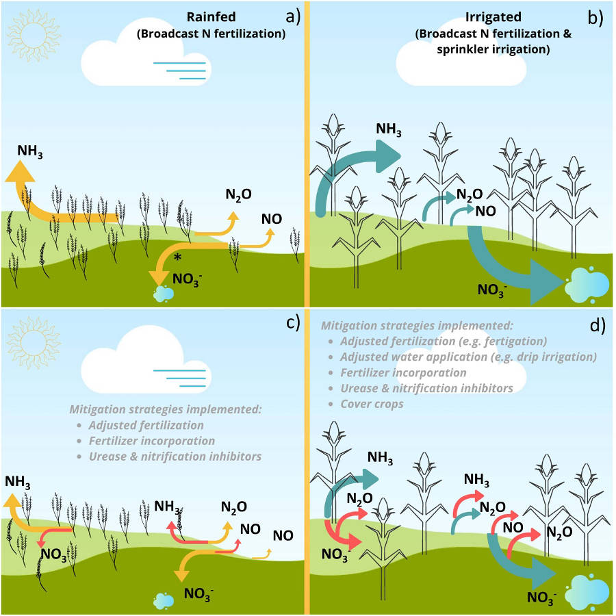
Worldwide, Mediterranean cropping systems face the complex challenge of producing enough high-quality food while preserving the quantity and quality of scarce water for people and agriculture in the context of climate change. While good management of nitrogen (N) is paramount to achieving this objective, the efficient strategies developed for temperate systems are often not adapted to the specificities of Mediterranean systems. In this work we combined original data with a thorough literature review to highlight the most relevant drivers of N dynamics in these semiarid systems. To do so, we provide an analysis at nested scales combining a bottom–up approach from the field scale with a top–down approach considering the agro-food system where cropping systems are inserted. We analyze the structural changes in the agro-food systems affecting total N entering the territory; the contrasting response of yields to N availability under rainfed and irrigated conditions in a precipitation gradient; the interaction between N management and climate change adaptation; the main drivers affecting the release of Nr compounds (NO3-, NH3, NO, N2O) as compared with temperate systems; and finally, the behavior of N once exported to highly regulated river networks. We conclude that a sustainable N management in Mediterranean cropping systems requires the specific adaptation of practices to the particular local agroenvironmental characteristics with special emphasis on water availability for rainfed and irrigated systems. This approach should also include a systemic analysis of N inputs into the territory that are driven by the configuration of the agro-food system.
A process-based soil erosion model ensemble to assess model uncertainty in climate change impact assessments
Land Degradation & Development 32 (7): 2409-2422, 2021
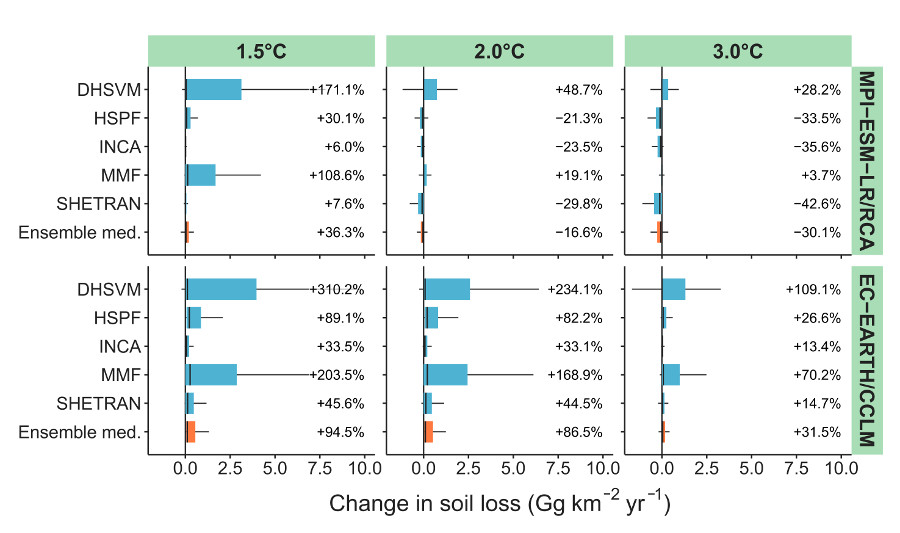
The impact of climate change on future soil loss is commonly assessed with soil erosion models, which are suggested to be an important source of uncertainty. Here we present a novel soil erosion model ensemble to assess model uncertainty in climate change impact assessments. The model ensemble consisted of five continuous process-based soil erosion models that run at a daily time step (i.e. DHSVM, HSPF, INCA, MMF, SHETRAN). The models were implemented in the SPHY hydrological model and simulate detachment by raindrop impact, detachment by runoff and immediate deposition. The soil erosion model ensemble was applied in a semi-arid catchment in the southeast of Spain. We applied three future climate scenarios based on global mean temperature rise (+1.5, +2 and +3 °C). Data from two contrasting regional climate models were used to assess how an increase and a decrease in projected extreme precipitation affect model uncertainty. Soil loss is projected to increase (up to 95%) and decrease (up to -30%) under climate change, mostly reflecting the change in extreme precipitation. Model uncertainty is found to increase with increasing slope, extreme precipitation and runoff, which reveals some inherent differences in model assumptions among the five models. Moreover, the model uncertainty increases in all climate change scenarios, independent of the projected change in annual precipitation and extreme precipitation. This stresses the importance to consider model uncertainty through model ensembles of climate, hydrology, and soil erosion in climate change impact assessments.
Macroinvertebrate taxonomical and trait-based responses to large wood re-introduction in lowland streams
Freshwater Science 39 (4): 2020
In hydromorphologically-degraded lowland streams, large-wood reintroductions are often used to re-establish instream physical structure, which might also increase biodiversity. However, the success rate of this approach varies in terms of positive macroinvertebrate assemblage responses. To obtain better insight into macroinvertebrate–wood relationships, we studied macroinvertebrate assemblage composition and its associated ecological and functional traits in 3 lowland streams in The Netherlands where wood was reintroduced. We used a before–after control–impact design in which we studied stream sections in 3 y: 1 y before and 2 y after large wood was added to some stream sections but not others. We recorded changes in physical structure expressed as substrate diversity, complexity, patchiness, and stability and then compared these parameters within and among the control and treated sections in each stream. We also sampled macroinvertebrates to determine whether the assemblage composition changed because of the wood addition. Finally, we assessed whether changes in macroinvertebrate assemblage could be related to taxa preferences for substrate type and flow and to their functional traits related to mode of locomotion and feeding type. Habitat heterogeneity increased after the wood additions and was relatively stable between years. Macroinvertebrate assemblages changed relative to the control sections in the 2 y after introduction, with 50 to 58% of the taxa increasing or decreasing significantly in abundance. Despite the changes in substrate composition and habitat heterogeneity, most of the functional relationships we expected between macroinvertebrates and large wood were either not apparent or site specific. The only characteristic shared by the macroinvertebrates that consistently increased in response to wood additions was a high affinity for hard substrates. In 1 stream we also observed an increase in taxa with a preference for high-flow velocity and a grazer–scraper feeding mode. These findings suggest that an increase in the surface area of stable, hard substrate was the main underlying ecological effect of reintroducing large wood to the stream channel of sand-bed lowland streams, at least in the short term, and that this change only affected a specific part of the macroinvertebrate assemblage. Changes in assemblage composition occurred primarily during the 1st y after the wood additions and decreased between the 1st and 2nd y, so colonization in this early successional stage seems to be limited to the species pool present in the immediate surroundings.
Wood-induced backwater in lowland streams
River Research and Applications 36 (7): 1171-1182, 2020
Placement of wood in streams has become a common method to increase ecological values in river and stream restoration and is widely used in natural environments. Water managers, however, are often hesitant to introduce wood in channels that drain agricultural and urban areas because of backwater concerns. This study aims to understand and predict wood-induced backwater in lowland streams in different natural conditions. Water levels upstream and downstream of wood patches were hourly gauged and collected for four streams in the Netherlands. Directly after wood insertion, the water level drop over the wood patch increased significantly by 0.1 m relative to a water depth of 0.5 m before wood insertion. The water level drop was found to increase with discharge, up to a certain maximum. If the discharge increased beyond this maximum, the water level drop reduced to the value that may represent the situation without wood. This reduction predominately depends on the obstruction ratio, calculated as the area covered by wood in the channel cross-section divided by the total cross-section area. In addition, morphologic adjustments in the stream and reorientation of the woody material reduced the water level drop over the patches in time. A newly developed, one-dimensional stationary model demonstrates that backwater effects can be reduced by optimizing the location where wood patches are placed, and by manipulating the obstruction ratio. The model can therefore function as a generic tool to achieve a stream design with wood that optimizes the hydrological and ecological potential of streams.
The impact of reservoir construction and changes in land use and climate on ecosystem services in a large Mediterranean catchment
Journal of Hydrology 590: 125208, 2020
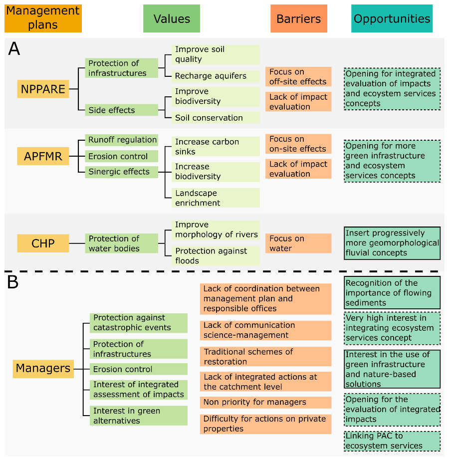
The Mediterranean region has been identified as one of the most affected global hot-spots for climate change, which is already manifested by faster increasing temperatures than the global mean and significant decreases in annual precipitation. Besides, over the past decades, important land cover changes have occurred, such as reforestation, agricultural intensification, urban expansion and the construction of many reservoirs. Here we study the impacts of these changes in a typical large Mediterranean catchment and focus on relevant ecosystem services, i.e. primary production, water supply, food production, water regulation, flood and erosion control, and cultural ecosystem services. We applied a hydrological model, coupled with a soil erosion and sediment transport model, for the period 1971-2010 to the entire catchment, and for an extended period (1952-2018), with more pronounced land use changes, to one of its subcatchments that plays a crucial role for regional drinking water provision. Climate change in the evaluated period is characterized by a decrease in precipitation and an increase in temperature. Land use changes included an increase in natural vegetation in the headwaters, agricultural intensification and reservoir construction in the central part, and urban expansion in the downstream part of the catchment. The positive impacts on ecosystem services were quantified by a decrease in hillslope erosion, sediment yield, sediment concentration and flood discharge, which are mainly attributed to climate change and reservoir construction. The negative impacts were quantified by an increase in plant water stress and a decrease in reservoir storage, for which the latter is mainly attributed to reforestation in the headwater catchments. While grey infrastructures like reservoir construction showed important positive impacts on some ecosystem services, such as water regulation and flood control, they also potentially induce negative impacts, such as an increase of water demand and ecological integrity. We argue that a shift is needed to green infrastructures and nature based solutions, such as reforestation and sustainable land management, which may lead to similar benefits on ecosystem services, but without the negative impacts caused by grey infrastructures. This supports the need for integrated land-use management to sustainably protect ecosystem services, considering the expected climate change impacts on Mediterranean environments and societies.
Mountain ecosystem services affected by land use changes and hydrological control works in Mediterranean catchments
Ecosystem Services 44: 101136, 2020
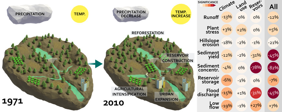
The use of check-dams in mountain environments to regulate fluxes of water and sediments is widely applied across Mediterranean mountains. Besides the use of “grey infrastructures” such as check-dams, other restoration and hydrological control measures rely more on the use of “green infrastructures” or “nature-based solutions” (e.g. reforestation, buffer lines) or a combination of both types of measures. It is widely accepted that both are complementary, and that prioritization should be based on economic, ecological and cultural criteria. This paper brings together all the knowledge generated during more than one decade concerning the impact of land use changes, reforestation, and hydrological control works on several ecosystem services in a representative Mediterranean catchment. The work evaluates different management scenarios aiming to optimize provision of ecosystem services in the area. The study area is a medium-sized catchment (∼300 km2) in Southeast Spain, representative of Mediterranean mountains that experienced agricultural land abandonment, greening up, and restoration works in the second half of the twentieth century. The methods combined: (i) previous research results for the area that were organized in an ecosystem services framework, providing data for three representative scenarios of catchment management; (ii) the use of value content analysis of the existing management plans for the area to understand the view of the managers; and (iii) a multicriteria analysis of the management scenarios to determine the most sustainable scenario to optimize different ecosystem services. The results of the evaluation were later validated with the stakeholders (technicians and managers involved in the management plans) through interviews. Our results show that solutions that respect landscape and ecological dynamics are more sustainable and cheaper in the medium and long term than scenarios based on “grey infrastructures”, although the latter could have more desirable short-term impacts. The value analysis reflects how there are some concepts, such as ecosystem services, that could easily be further incorporated into several management plans. When choosing a management scenario, this needs to be adapted to the local environmental conditions and to the specific objectives of the restoration works. Tailor-made management scenarios taking into account two factors (local conditions and specific management objectives) can optimize resources and achieve medium to long-term sustainability.
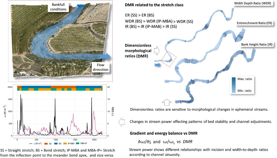
Dimensionless morphological ratios versus stream power variations at bankfull stage in an ephemeral channel
Geomorphology 361: 107199, 2020
Dimensionless morphological ratios (DMR) generally are used in systemic proposals for stream classification and river restoration projects. Often, such morphometric parameters, including field data from channel cross sections, develop into a template for a given geomorphic reference site. In this study, high-resolution Digital Terrain Models (HRDTMs), combined with orthophotographs from 2018 and ground-based surveys, were used to analyze the spatial variability of DMR in a semi-arid ephemeral stream subject to changes in stream power under bankfull conditions. In particular, a channel reach of 2.7 km in length along the Upper Mula stream in southeastern Spain was chosen to test the relationships between the two types of variables. Rosgen’s DMR (width to depth ratio, entrenchment ratio, bank height ratio) and hydraulic data at bankfull stage (flow velocity, Froude number, shear stress, mean stream power and energy gradient, among others) were calculated by 1D hydrodynamic modeling and HRDTMs prior entry of field information. The resulting maps allowed comparison of stream power with DMR in relation to the channel stretch class and bed stability. The results showed similar spatial patterns for the width to depth ratio and the bank height ratio. The average values estimated in bend stretches were lower than along straight and slightly sinuous stretches and very similar to those of sub-reaches from the inflection point to the meander bend apex. However, the entrenchment ratio followed a different pattern, according to which the straight and slightly sinuous stretches were the most entrenched and the bend stretches presented a more moderate average entrenchment ratio. In addition, the energy balance and power gradient also experienced spatial variations in relation to the bed stability and DMR. Only in highly incised sub-reaches were such relationships not significant. The lack of a significant correlation between excess energy and bank height ratio or width to depth ratio over short lag distances was also verified, regardless of the affected bedforms. An ANOVA showed important differences between the straight and slightly sinuous stretches and bend stretches, which were strongly influenced by the incision and entrenchment ratios and the maximum bankfull depth.
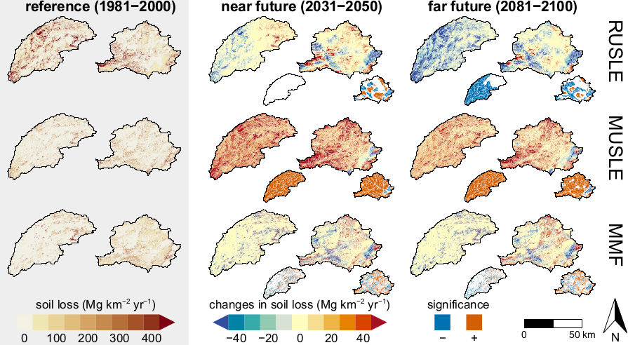
How soil erosion model conceptualization affects soil loss projections under climate change
Progress in Physical Geography 44 (2): 212-232, 2020
Climate models project increased extreme precipitation for the coming decades, which may lead to higher soil erosion in many locations worldwide. Different soil erosion model concepts are used to assess the impact of climate change on soil erosion at large spatial scales, including models forced by precipitation and by runoff. However, there is little knowledge of the implications of soil erosion model conceptualization on projected soil erosion rates under climate change. Here we assessed the impact of climate change with the three most widely used soil erosion model concepts, i.e. a model forced by precipitation (RUSLE), a model forced by runoff (MUSLE), and a model forced by precipitation and runoff (MMF). We applied the models to two contrasting Mediterranean catchments (SE Spain), where climate change is projected to decrease the annual precipitation sum and increase extreme precipitation, based on the RCP8.5 climate change scenario. Depending on the model, soil erosion is projected to decrease (RUSLE) or increase (MUSLE and MMF) in the study area. While it is difficult to validate future model projections, the differences between the model projections are inherently a result of their model conceptualization, such as a decrease of soil loss due to decreased annual precipitation sum (RUSLE) and an increase of soil loss due to increased extreme precipitation and, consequently, increased runoff (MUSLE). An intermediate result is obtained with MMF, where a projected decrease in detachment by raindrop impact is counteracted by a projected increase in detachment by runoff. We conclude that in climate change impact assessments it is important to select a soil erosion model that is forced by both precipitation and runoff, which under climate change may have a contrasting effect on soil erosion.
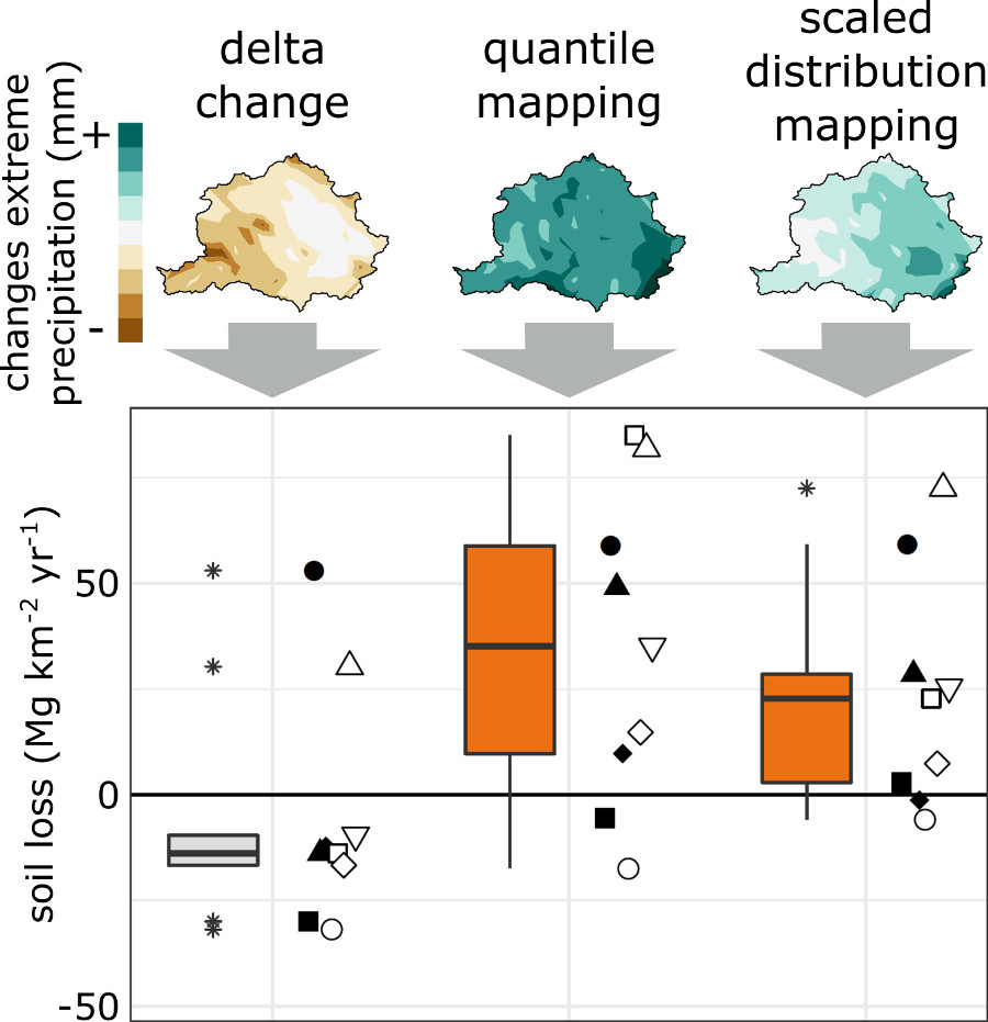
The implications of bias-correction methods and climate model ensembles on soil erosion projections under climate change
Earth Surface Processes and Landforms 44 (5): 1137-1147, 2019
Climate change will most likely cause an increase of extreme precipitation and consequently an increase of soil erosion in many locations worldwide. In most cases, climate model output is used to assess the impact of climate change on soil erosion, however, there is little knowledge of the implications of bias‐correction methods and climate model ensembles on projected soil erosion rates. Using a soil erosion model, we evaluated the implications of three bias‐correction methods (delta change, quantile mapping and scaled distribution mapping) and climate model selection on regional soil erosion projections in two contrasting Mediterranean catchments. Depending on the bias‐correction method, soil erosion is projected to decrease or increase. Scaled distribution mapping best projects the changes in extreme precipitation. While an increase in extreme precipitation not always results in increased soil loss, it is an important soil erosion indicator. We suggest to first establish the deviation of the bias‐corrected climate signal with respect to the raw climate signal, in particular for extreme precipitation. Furthermore, individual climate models may project opposite changes with respect to the ensemble average, hence, climate model ensembles are essential in soil erosion impact assessments to account for climate model uncertainty. We conclude that the impact of climate change on soil erosion can only accurately be assessed with a bias‐correction method that best reproduces the projected climate change signal, in combination with a representative ensemble of climate models.
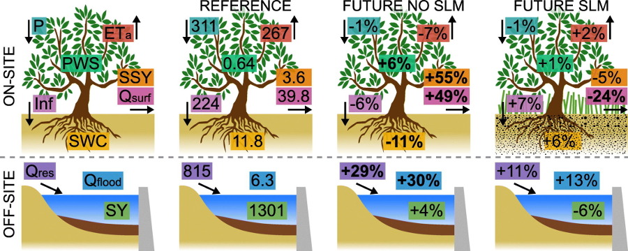
Assessing the effectiveness of Sustainable Land Management for large-scale climate change adaptation
Science of The Total Environment 654: 85-93, 2019
Climate change will strongly affect essential ecosystem services, like the provision of freshwater, food production, soil erosion and flood control. Sustainable Land Management (SLM) practices are increasingly promoted to contribute to climate change mitigation and adaptation, but there is lack of evidence at scales most relevant for policymaking. We evaluated the effectiveness of SLM in a large Mediterranean catchment where climate change is projected to significantly reduce water security. We show that the on-site and off-site impacts of climate change are almost entirely reversed by the large-scale implementation of SLM under moderate climate change conditions, characterized by limited reductions in annual precipitation but significant increased precipitation intensity. Under more extreme reductions of annual precipitation, SLM implementation reduces the impacts on water security, but cannot prevent significant increased plant water stress and reduced water availability. Under these conditions, additional adaptation measures are required considering their interactions and trade-offs regarding water security.
Why increased extreme precipitation under climate change negatively affects water security
Hydrology and Earth System Sciences 22 (11): 5935-5946, 2018
An increase in extreme precipitation is projected for many areas worldwide in the coming decades. To assess the impact of increased precipitation intensity on water security, we applied a regional-scale hydrological and soil erosion model, forced with regional climate model projections. We specifically considered the impact of climate change on the distribution of water between soil (green water) and surface water (blue water) compartments. We show that an increase in precipitation intensity leads to a redistribution of water within the catchment, where water storage in soil decreases and reservoir inflow increases. This affects plant water stress and the potential of rainfed versus irrigated agriculture, and increases dependency on reservoir storage, which is potentially threatened by increased soil erosion. This study demonstrates the crucial importance of accounting for the fact that increased precipitation intensity leads to water redistribution between green and blue water, increased soil erosion, and reduced water security. Ultimately, this has implications for design of climate change adaptation measures, which should aim to increase the water holding capacity of the soil (green water) and to maintain the storage capacity of reservoirs (blue water), benefiting rainfed and irrigated agriculture.
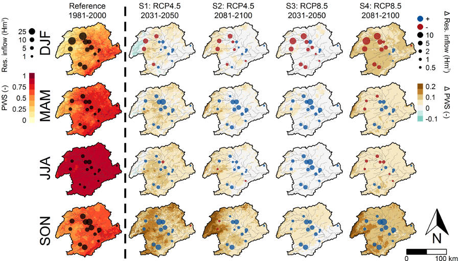
Assessing the large-scale impacts of environmental change using a coupled hydrology and soil erosion model
Earth Surface Dynamics 6 (3): 687-703, 2018
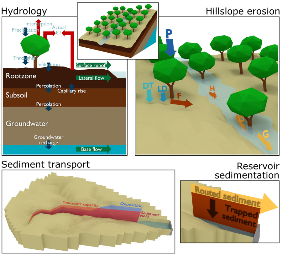
Assessing the impacts of environmental change on soil erosion and sediment yield at the large catchment scale remains one of the main challenges in soil erosion modelling studies. Here, we present a process-based soil erosion model, based on the integration of the Morgan–Morgan–Finney erosion model in a daily based hydrological model. The model overcomes many of the limitations of previous large-scale soil erosion models, as it includes a more complete representation of crucial processes like surface runoff generation, dynamic vegetation development, and sediment deposition, and runs at the catchment scale with a daily time step. This makes the model especially suited for the evaluation of the impacts of environmental change on soil erosion and sediment yield at regional scales and over decadal periods. The model was successfully applied in a large catchment in southeastern Spain. We demonstrate the model’s capacity to perform impact assessments of environmental change scenarios, specifically simulating the scenario impacts of intra- and inter-annual variations in climate, land management, and vegetation development on soil erosion and sediment yield.
Flow thresholds for leaf retention in hydrodynamic wakes downstream of obstacles
Ecohydrology 10 (7): e1883, 2017
Leaves are the major component of terrestrial litter input into aquatic systems. Leaves are distributed by the flow, accumulate in low flow areas, and form patches. In natural streams, stable leaf patches form around complex structures, such as large woody debris. Until now, little is known about flow conditions under which leaf patches persist. This study aims to quantify flow conditions for stable leaf patches and entrainment of leaf patches. We hypothesize that entraining flow processes, such as turbulence, Reynolds stress, or lift forcing (vertical flow velocity), best explain local leaf retention. This study was performed in an unscaled flume experiment, which conditions coincide with conditions found in low‐energetic lowland streams. We positioned a wooden obstacle perpendicular to the flow on the bed of the flume. A leaf patch was positioned downstream from the wooden obstacle. The experiment was performed under 5 flow conditions. We monitored leaf patch cover and near‐bed flow conditions in the area downstream of the wooden obstacle. We showed that near‐bed flow velocities explain leaf retention better than more complex flow velocity derivatives such as turbulence, Reynolds stress, and vertical flow velocity. The entrainment near‐bed flow velocity for leaves ranges from 0.037 to 0.050 m/s. Flow velocities frequently exceed those values, even in low‐energetic lowland streams. Therefore, complex structures, such as woody debris, create flow conditions to support stable leaf patches. Thus, adding instead of removing obstacles may be a key strategy in restoring biodiversity in deteriorated streams.
Hydrological Modelling using Satellite-Based Crop Coefficients: A Comparison of Methods at the Basin Scale
Remote Sensing 9 (2): 174, 2017
The parameterization of crop coefficients (kc) is critical for determining a water balance. We used satellite-based and literature-based methods to derive kc values for a distributed hydrologic model. We evaluated the impact of different kc parametrization methods on the water balance and simulated hydrologic response at the basin and sub-basin scale. The hydrological model SPHY was calibrated and validated for a period of 15 years for the upper Segura basin (~2500 km2) in Spain, which is characterized by a wide range of terrain, soil, and ecosystem conditions. The model was then applied, using six kc parameterization methods, to determine their spatial and temporal impacts on actual evapotranspiration, streamflow, and soil moisture. The parameterization methods used include: (i) Normalized Difference Vegetation Index (NDVI) observations from MODIS; (ii) seasonally-averaged NDVI patterns, cell-based and landuse-based; and (iii) literature-based tabular values per land use type. The analysis shows that the influence of different kc parametrization methods on basin-level streamflow is relatively small and constant throughout the year, but it has a bigger effect on seasonal evapotranspiration and soil moisture. In the autumn especially, deviations can go up to about 15% of monthly streamflow. At smaller, sub-basin scale, deviations from the NDVI-based reference run can be more than 30%. Overall, the study shows that modeling of future hydrological changes can be improved by using remote sensing information for the parameterization of crop coefficients.
Morphological assessment of reconstructed lowland streams in the Netherlands
Advances in Water Resources 81: 161-171, 2015
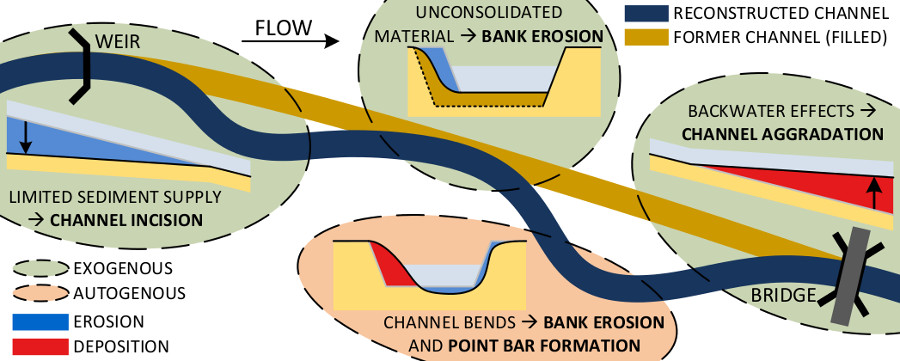
Channelisation measures taken halfway the 20th century have had destructive consequences for the diversity of the ecology in the majority of the lowland streams in countries such as the Netherlands. Re-meandering is the common practice in restoring these lowland streams. Three reconstructed streams were monitored during the initial two years after construction of a new channel. The monitoring program included morphological surveys, sediment sampling, habitat pattern surveys, and discharge and water level measurements. Adjustments of the longitudinal bed profile formed the main morphological response. These adjustments were most likely caused by a lack of longitudinal connectivity of the streams as a whole, interrupting transport of sediment at locations of weirs and culverts. Bank erosion was observed only in a limited number of channel bends, and was often related to floodplain heterogeneity. Longitudinal channel bed adjustments and bank erosion were mainly caused by exogenous influences. In channel bends, the cross-sectional shape transformed from trapezoidal to the typical asymmetrical shape as found in meandering rivers. This behaviour can be attributed to an autogenous response to the prevailing flow conditions. Due to the prevailing fine sediment characteristics, bed material is readily set in motion and is being transported during the entire year. The existing design principles fail to address the initial morphological development after reconstruction. An evaluation of pre-set targets to realise water depth and flow velocity ranges shows the current procedures to be deficient. Based on this unfavourable evaluation, and the two-dimensional nature of habitat patterns needed to improve the conditions for stream organisms, we recommend to predict morphological developments as part of the design procedures for lowland stream restoration in the Netherlands.
Chute cutoff as a morphological response to stream reconstruction: The possible role of backwater
Water Resources Research 51 (5): 3339-3352, 2015
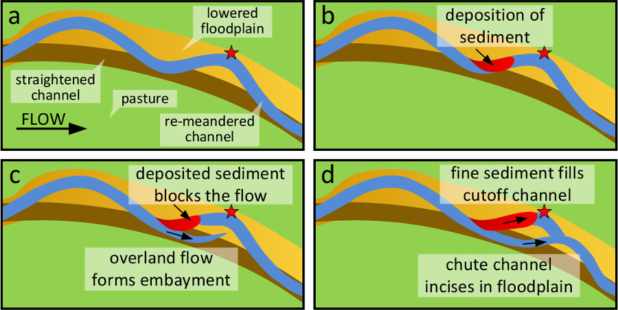
Stream restoration efforts often aim at creating new unconstrained meandering channels without weirs and bank revetments. In reconstructed streams, the initial morphological response of the new streams is often rapid, until a dynamic equilibrium is reached. Here we report on a chute cutoff that occurred within 3 months after realization of a stream restoration project, caused by a plug bar that formed in response to a backwater effect. The temporal evolution of the morphology of both the new and the old channels was monitored over a period of nearly 8 months, including precutoff conditions. The observations can be separated into three stages. Stage 1 is the initial period leading to cutoff vulnerability, stage 2 is the actual cutoff, and stage 3 is the morphological adjustment in response to the cutoff. In stage 1, a plug bar was deposited in one of the channel bends. Hydrodynamic model results show the location of the plug bar coincides with a region where bed shear stress decreased in downstream direction due to backwater. Longitudinal channel bed profiles show that the channel slope decreased soon after channel reconstruction. Hence, sediment from upstream was available to form the plug bar. After the plug bar was deposited, an embayment formed in the floodplain at a location where the former channel was located (stage 2). The former channel was filled with sediment prior to channel construction. It is likely that the sediment at this location was less consolidated, and therefore, prone to erosion. The chute channel continued to incise and widen into the floodplain and, after 6 months, acted as the main channel, conveying the discharge during the majority of time (stage 3). The cutoff channel gradually continued to fill with sediment, from the moment the plug bar formed until the chute channel incised into the floodplain. Sedimentary successions of the deposited material show upward fining, which is in agreement with observations of chute cutoffs in rivers. Although the artificial setting limits the degree in which the observed processes can be projected on natural rivers, the observations prompt to investigate the role of backwater effects in natural chute cutoff initiation.
Morphodynamic regime change in a reconstructed lowland stream
Earth Surface Dynamics 2: 279-293, 2014
With the aim to establish and understand morphological changes in response to channel reconstruction, a detailed monitoring plan was implemented in a lowland stream called Lunterse Beek, located in the Netherlands. Over a period of almost 2 years, the monitoring programme included serial morphological surveys, continuous discharge and water level measurements, and riparian vegetation mapping, from photographs and field surveys. Morphological processes occurred mainly in the initial period, before riparian vegetation developed. The initial period was largely dominated by upstream sediment supply, which was associated with channel incision upstream from the study area. Herbaceous vegetation started to develop approximately 7 months after channel reconstruction. The monitoring period included two growing seasons. A clear increase of riparian vegetation cover from first to the second year was observed. Detailed morphological and hydrological data show a marked difference in morphological behaviour between the pre-vegetation and post-vegetation stage. A linear regression procedure was applied to relate morphological activity to time-averaged Shields stress. In the initial stage after channel reconstruction, with negligible riparian vegetation, channel morphology adjusted, showing only a weak response to the discharge hydrograph. In the subsequent period, morphological activity in the channel showed a clear relation with discharge variation. The two stages of morphological response to the restoration measures may be largely associated with the upstream sediment supply in the initial period. Riparian vegetation may have played a substantial role in stabilizing the channel banks and floodplain area, gradually restricting the morphological adjustments to the channel bed.
Field experiment on alternate bar development in a straight sand-bed stream
Water Resources Research 49 (12): 8357–8369, 2013
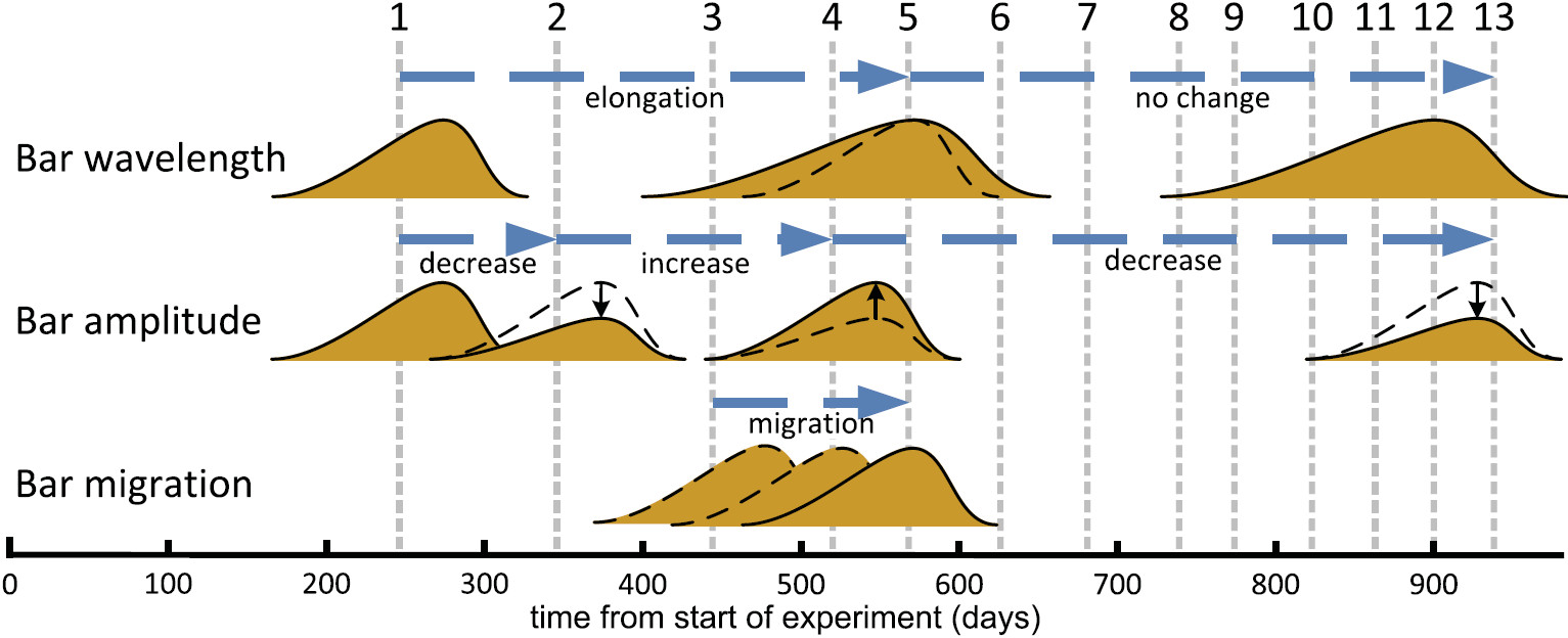
Alternate bars in rivers and streams develop as a result of differences in length scales involved in the adjustment of flow and sediment transport to irregularities of the bed. The amount of field evidence supporting theoretical insights is highly limited. Here, we present results from a large-scale field experiment in a 600 m long straight reach. Over a period of almost 3 years, the channel was allowed to evolve autogenously from initially flat bed conditions, subject to discharge variation. Alternate bars developed within 8 months from the start of the experiment. The initial stages of bar development included bar growth, both in wavelength and amplitude, and bar migration. The latter was too limited to classify the bars as being migrating bars; therefore, we classify the bars as nonmigrating bars. Toward the end of the experiment, the regular alternate bar pattern evolved into an irregular pattern and bar amplitude started to decrease. From the start of the experiment we observed a declining channel slope, from 1.8 m/km initially to 0.9 m/km halfway the experiment, after which it stabilized. We applied two bar theories to establish their predictive capacity. Both bar theories predicted the development of alternate bars under the constructed channel conditions. In response to the declining channel slope, both theories predicted a decreasing likelihood for the development of alternate bars. Our study shows that under field conditions, the applied bar theories may predict the initial stages of bed development.
Historical analysis indicates seepage control on initiation of meandering
Earth Surface Processes and Landforms 38 (8): 888–897, 2013
In analytical and numerical models of river meandering, initiation of meandering typically occurs uniformly along the streamwise coordinate in the channel. Based on a historical analysis of the Nierskanaal, here we show how and under which circumstances meandering has initiated in isolated sections of a channel. The Nierskanaal was constructed by the end of the 18th century, as a straight channel between the river Niers and the river Meuse. The purpose of this measure was to reduce flood risk in the downstream reaches of the river Niers. The banks on the Dutch part of the channel were left unprotected and developed into a morphodynamically active channel, featuring a meandering planform and valley incision. The planform development and incision process is analysed using topographic maps and airborne LiDAR data. Meandering initiated in three sections of the channel, where the channel sinuosity developed asynchronously. Sedimentary successions in the study area show layers of iron oxide, indicating groundwater seepage from aeolian river dunes and river deposits located nearby. Only at the spots where meandering has initiated iron oxide is found close to the surface level. This provides a clue that seepage triggered bank erosion by increasing moisture content of the banks. The isolated meandering sections expanded in the longitudinal direction. Valley incision has developed in the first decades after the construction of the channel, and diminished after a gravel layer was reached. Gravel was deposited in the downstream half of the channel bed, acting as an armouring layer. The spatial variation in meandering behaviour, as observed in the Nierskanaal, justifies efforts to implement the influence of floodplain heterogeneity and the effect of seepage on bank erosion in meander models.
Conference proceedings
Assessing the effectiveness of Sustainable Land Management for large-scale climate change adaptation
Proceedings Global Symposium on Soil Erosion: 410-414, 2019
Climate change will strongly affect essential ecosystem services, like the provision of freshwater, food production, soil erosion and flood control. Sustainable Land Management (SLM) practices are increasingly promoted to contribute to climate change adaptation, but there is lack of evidence at scales most relevant for policymaking. We evaluated the effectiveness of SLM in a large Mediterranean catchment where climate change is projected to significantly reduce water security. We show that the on-site and off-site impacts of climate change are almost entirely reversed by the large-scale implementation of SLM under moderate climate change conditions, characterized by limited reductions in annual precipitation but significant increased precipitation intensity. Under more extreme reductions of annual precipitation, SLM implementation reduces the impacts on water security, but cannot prevent significant increased plant water stress and reduced water availability. Under these conditions, additional adaptation measures are required considering their interactions and trade-offs regarding water security and soil erosion.
Field-scale experiment on migrating bar dynamics: preliminary analysis
River Flow 2012: Proceedings of the sixth edition of the international conference on fluvial hydraulics: 623-627, San Jose, Costa Rica, September 5-7, 2012
Within the Dutch research project ’Valley wide meander restoration’ six restored streams will be monitored over a 2-year period. The monitoring program aims at understanding initial morphological processes and the associated ecological developments. The present study focuses on the morphodynamic developments that took place after the completion of one of the restoration projects. The morphology and hydraulics of the field sites are evaluated using sequential GPS-surveys, discharge records and information from sediment samples. The present contribution concerns the Hooge Raam, where a new channel is constructed parallel to the stream that was to be restored. The channel was designed to investigate the autogenous formation of a meandering channel from an initially straight reach, designed based on hydraulic geometry relations. Eight months after construction of the stream, alternating bars emerged in the downstream part of the stream. Analysis of ten successive bed level surveys about two months apart shows channel bar migration and an increase of both the bar height and their wavelengths. Bar wavelength is increasing in time until it reaches an equilibrium value. The dynamics of both migration speed and bar height respond to the dynamics in the varying discharge.
Field-scale experiment of migrating bar behavior: preliminary analysis
EUROMECH Colloquium 523, Ecohydraulics: linkages between hydraulics, morphodynamics and ecological processes in rivers: 207-211, Clermont-Ferrand, France, June 15-17, 2011
